Online Maps are currently unavailable due to maintenance.
If you need particular maps, please call the shire of (08) 9071 0666 or email shire@esperance.wa.gov.au.
The Landgate Map is available in the meantime.
If you are searching for information relating to a particular property, you can look up the address and detailed, up-to-date information will appear instantly.
Using Intramaps
The digital map has a number of layers, themes, views and modules that you can activate to view different types of information, such as wards, elected members, planning and zoning information and rubbish collection dates. You can also view aerial photographs or explore local topographical information.
If you are searching for information relating to a particular property, you can look up the address and detailed information will appear instantly.
Accessibility disclaimer
IntraMaps is provided by a third party. The Shire of Esperance regrets it cannot guarantee the accessibility of this application.
IntraMap tools
Selection tool
Allows you to select properties and display information in the information panel.

Navigation tool
Allows you to zoom in and out as well as step backwards, forward and between zooms.

Measuring tool
Allows you to measure distances and area. Point and click where you wish to measure and double click to finish.

IntraMap modules
The module drop down list allows a map module to be selected and displayed.
The modules available include:
- General Enquiry
- Planning
- Aerial Imagery
Using search
Use the search function to find a property. Simply enter the street number and street name.
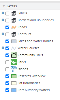
Using layers

Visible icon display
The visible icon display shows the available information for the current selected layer. Icons can be toggled on and off as desired.
Label icon display
Like the visible icon display, the label icon display shows the default labels, which can be turned on and off as required by the user.